Complete Rental Walkthrough including Float Planning

Washburn Wisconsin
We are located in Washburn Wisconsin on Highway 13 and County C. We launch at the Washburn Marina for better facilities. Note the West End Launch ramp is not our preferred launch point.

West End old Logging Mill
The nautical chart still shows remnants of the old logging mill at Washburn’s West End—a historic site now serving modern boaters. While the area has character, underwater debris from the mill can pose hazards. That’s why we prefer launching from the Washburn Marina, located just a mile east. But for the Jet Boat Scarab Ghost with out a propeller this launch ramp is closer.

Large Marina
Washburn Marina is home to the only 100-ton travel lift on western Lake Superior, making it a vital service hub for large industrial vessels across the region. It also features one of the best-maintained and most accessible launch ramps on the lake—ideal for launching and retrieving our rental fleet. Conveniently located near the ramp are ample parking spaces and clean restroom facilities, making for a smooth and comfortable start to your day on the water.
-7644647.jpg/:/rs=w:1209,cg:true,m)
Chequamegon Bay
Chequamegon Bay and Madeline Island are your two closest options and perfect for relaxed 2-hour or easy 4-hour rentals.
Most boat renters head north from Washburn. The shoreline right there is loaded with tombolos, cliffs, and beautiful sea caves. Houghton Falls is a standout spot—definitely slow down and take it in. A little farther is Long Island, with its miles-long sand beach. The water stays relatively warm and the bottom is mostly sand, so it’s a favorite for locals to swim. Just be careful wading ashore so you don’t disturb the protected Piping Plovers.
If you’re up for crossing the bay to the south end of Madeline Island and the town of La Pointe, you’ll find a whole different vibe. Watch for an east wind—it can kick up some big waves in the South Channel. Once you’re there, La Pointe is great for shopping, dining, and soaking up island life. Two restaurants have docks for customers: The Pub and The Beach Club. There’s also a full-service marina with fuel docks.
La Pointe Madeline Island
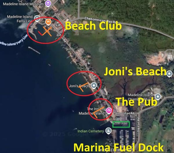
Madeline Island: A Must-Visit Boating Destination
The largest of the Apostle Islands and the only one with a town (La Pointe), Madeline Island is a fantastic spot to explore by boat. It offers:
- Public docks & a full-service marina
- Restaurants, bars & a coffee shop
- A museum & local attractions
Whether you're docking for a meal, sightseeing, or just soaking in the island vibe, Madeline Island has something for everyone!

Beach Club Dock
Beach Club dock is popular and you can walk around downtown La Pointe but please patronize the Beach Club as well for use of their dock.
Pub Dock
The Pub is next to the Madeline Island Yacht Club and has a nice dock for dining at The Pub.
West Channel and Basswood
The Basswood Quarry still has a large dock crib marked on the chart. Also north of the Casino is a Shipwreck The Fedora which is just below the surface. Further north in Schooner bay is more of a ship graveyard with abandonded shipwrecks in the shallow water.

Basswood, West and North Channels.
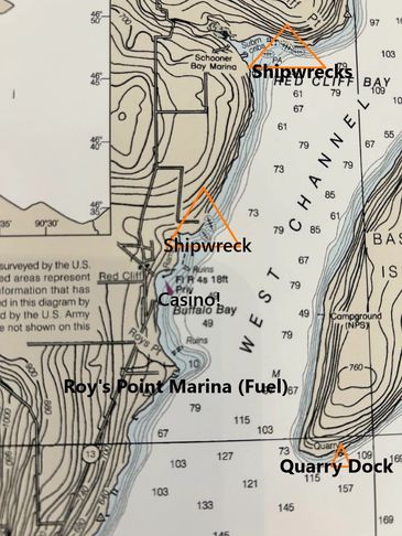
Roys Point is the North Most Fuel Dock
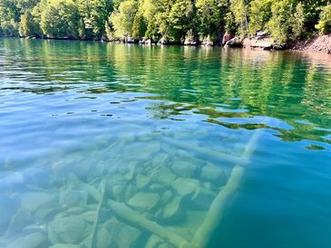
Quarry Dock
Docks are never removed from The Apostle Islands. They remain often just below the waterline and are usually marked on the chart. But anytime you are near enough to shore you could imagine a dock you should be moving slow with eyes in the water.
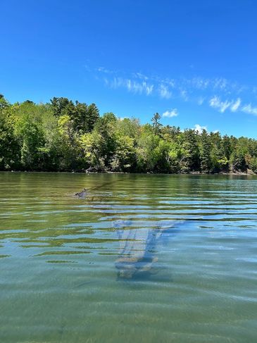
Fedora
Fedora
The Fedora isa in very shallow water. I highly suggest staying comlpetly aware from all the shipwrecks near shores and metal things can protrude suddenly.
Manitou Island and Little Manitou Rock Reef

Little Manitou and Big Manitou
Little Manitou and Big Manitou
Little Manitou and Big Manitou
The only rock reef the really jets out way far from shore is Little Manitou, and shallow water extends to shore so do not go between Little and Big Manitou
Little Manitou
Little Manitou and Big Manitou
Little Manitou and Big Manitou
The Park Service pays the seagulls to keep it painted white. There is a green square and light on it as a navagational aid.
Float Planning
You will receive a copy of my float plan map to mark up and take notes on during float planning.
I use a skiing difficulty analogy for the Apostle Islands area:
- Green Circle: Easier / closer waters (generally protected, smaller fetches)
- Blue Square: Intermediate
- Black Diamond: Advanced / exposed waters (longer distances, larger open water)
These ratings primarily reflect distance and the size of the water body, not just wave height. Conditions can vary significantly with wind:
- There can still be large waves even in Green Circle areas.
- Conversely, Devils Island and other outer Black Diamond areas can sometimes be surprisingly calm.
On certain wind days, I may describe the overall conditions as a “Blue Square day,” and Black Diamond areas may feature large waves or “moguls.” In more challenging conditions, I may simply advise: “Do not enter Black Diamond areas.”
